The United Arab Emirates has achieved another milestone in its growing space journey by releasing the first satellite images captured by MBZ-SAT and Etihad-SAT. The images, unveiled during World Space Week 2025, mark a defining moment in the nation’s quest for advanced Earth observation capabilities and technological independence.
A Milestone for the UAE
The release of the UAE first satellite images is more than a symbolic achievement. It is a demonstration of the country’s readiness to compete in the global space industry and its commitment to using satellite technology for environmental monitoring, disaster response, and national development.
The event highlights several key milestones. First, both MBZ-SAT and Etihad-SAT have successfully completed their early mission phases, confirming that their imaging systems are fully operational. Second, the UAE now possesses independent access to advanced Earth observation data, reducing reliance on foreign space agencies. Finally, this milestone sets the foundation for future international collaborations and commercial opportunities in the space data market.

MBZ-SAT: The Optical Powerhouse
Overview and Design
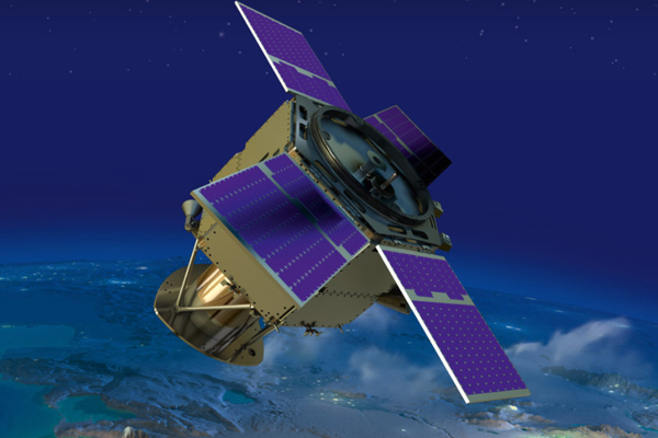
MBZ-SAT, named after President Sheikh Mohamed bin Zayed Al Nahyan, is the UAE’s most advanced optical Earth observation satellite. It was launched in January 2025 aboard a SpaceX Falcon 9 rocket from California. The satellite weighs around 750 kilograms and measures approximately three meters by five meters, making it one of the region’s largest domestically developed satellites.
Designed by the Mohammed Bin Rashid Space Centre (MBRSC), MBZ-SAT features advanced imaging systems capable of capturing ultra-high-resolution photographs of Earth’s surface. Nearly 90 percent of its mechanical components were built in the UAE, showcasing the country’s progress in local manufacturing and engineering expertise.

Advanced Features
MBZ-SAT offers several groundbreaking technological features:
- High-resolution imaging: It doubles the accuracy of earlier Emirati satellites, delivering sharper and more detailed images.
- Faster data delivery: The satellite transmits data four times faster than previous systems, allowing near real-time access to imagery.
- Automation: Using AI-based scheduling and onboard processing, MBZ-SAT can autonomously capture and process data within two hours of imaging.
- Electric propulsion: Its energy-efficient propulsion system ensures precise orbit control and longer mission life.
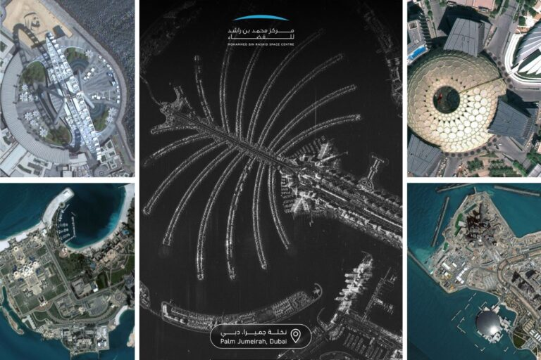
Captured Landmarks
Among the first images released by MBZ-SAT were breathtaking views of Expo City Dubai, Palm Jumeirah, and the Saadiyat Cultural District in Abu Dhabi. The images showcased the satellite’s ability to capture intricate urban details, reflecting both the beauty and the technological precision of the UAE.
Etihad-SAT: The Radar Companion
The Power of SAR Technology
While MBZ-SAT uses optical imaging, Etihad-SAT employs Synthetic Aperture Radar (SAR) technology. This allows it to capture images in all weather conditions, even at night or through thick cloud cover.
Etihad-SAT is the first SAR satellite developed by the MBRSC. It was launched in March 2025, weighing approximately 220 kilograms. Built in collaboration with South Korea’s Satrec Initiative, the project focused heavily on technology transfer and Emirati skill development.
Imaging Capabilities
Etihad-SAT operates in three main imaging modes:
- Spot mode: High-resolution imaging of specific small areas.
- Scan mode: Balanced coverage for medium-sized regions.
- Strip mode: Wide-area imaging for long terrain sections.
The radar-based imagery produced by Etihad-SAT is particularly valuable for environmental monitoring, maritime safety, and disaster management, as it can capture data regardless of light or weather conditions.
Among the first released images were radar views of Hudayriyat Island and Palm Jumeirah, providing remarkable detail of coastal and urban zones.
A Dual-Satellite Advantage
The combination of MBZ-SAT and Etihad-SAT gives the UAE a powerful dual-imaging system that covers nearly all conditions. While MBZ-SAT provides clear, color-rich optical visuals, Etihad-SAT ensures uninterrupted coverage with radar imaging.
This dual capability allows authorities and researchers to observe environmental changes continuously. For instance, if cloud cover obscures optical imagery, radar imaging from Etihad-SAT can fill the gap. Together, the satellites ensure consistent data for projects involving city planning, agriculture, and disaster management.
Real-World Applications
Disaster Response
The UAE first satellite images will significantly enhance disaster preparedness. High-resolution and radar data can help monitor flooding, detect wildfires, or assess damage after natural disasters, allowing for faster and more informed decision-making.
Agriculture and Water Management
Satellite data is invaluable for modern agriculture. Farmers and policymakers can use imagery to track soil moisture, monitor crop growth, and optimize irrigation. This contributes directly to sustainable food and water management.
Urban Planning and Infrastructure
High-resolution imagery supports smart city planning by providing accurate geographic data. Authorities can use this information to monitor construction, plan transportation networks, and analyze urban expansion.
Environmental Protection
From tracking mangrove health to observing desertification, these satellites will play a key role in environmental sustainability. They will also support research on climate change, land use, and ecological preservation.
Maritime and Security Applications
Radar data from Etihad-SAT can detect ships, oil spills, and illegal maritime activity. This improves border security and environmental safety in UAE waters.
Commercial and Research Potential
The imagery and data collected can be licensed to governments, universities, and private companies worldwide. This positions the UAE as a future leader in the commercial satellite data market, opening new revenue streams for the nation’s space economy.
The Journey to Success
The success of MBZ-SAT and Etihad-SAT is the result of years of planning, engineering, and international cooperation. The MBRSC led both projects with a clear focus on nurturing local expertise and building a sustainable space ecosystem.
Emirati engineers worked on every phase, from design to assembly and testing. The collaboration with international partners like SpaceX and Satrec Initiative provided vital exposure and technology transfer.
Each satellite underwent extensive testing to ensure resilience against harsh launch and space conditions. The ground control systems were also upgraded to handle faster data transmission, automation, and secure data storage.
The timing of the image release during World Space Week 2025 emphasized the UAE’s growing reputation as a hub for space research and innovation.
Voices from the UAE Space Community
Leaders from the Mohammed Bin Rashid Space Centre hailed the successful release as a national milestone. Hamad Obaid Al Mansoori, Chairman of MBRSC, described the achievement as a reflection of the UAE’s vision for innovation and excellence in science and technology. Salem Humaid Al Marri, Director General of MBRSC, highlighted that MBZ-SAT and Etihad-SAT represent a unified national effort to expand Earth observation capabilities and strengthen the UAE’s space industry.
Public response was equally enthusiastic. Social media platforms were filled with posts celebrating the crystal-clear images of Dubai and Abu Dhabi captured from space. Many viewed the achievement as a moment of pride for the nation and a demonstration of Emirati talent and ambition.
Challenges and Future Outlook
Despite the success, the UAE’s space journey faces ongoing challenges such as data management, calibration accuracy, and satellite maintenance. However, these challenges also create opportunities for innovation and capacity building.
The UAE plans to continue expanding its satellite fleet, potentially adding hyperspectral and smaller satellite constellations to improve revisit rates and global coverage. Investment in artificial intelligence and machine learning will further enhance image processing and predictive analytics.
In the long term, the nation aims to establish itself as a regional leader in satellite manufacturing and data analytics, offering services that extend beyond the Middle East. Educational initiatives and new research programs are expected to inspire future generations of Emirati scientists and engineers.
Conclusion
The release of the UAE first satellite images from MBZ-SAT and Etihad-SAT is a remarkable achievement that cements the country’s position in the global space landscape. These satellites are not only technological assets but also symbols of national progress, innovation, and resilience.
Through their combined optical and radar capabilities, they will play a vital role in advancing scientific research, sustainable development, and economic diversification.
As the UAE continues to push the boundaries of space exploration and technology, this milestone will be remembered as the moment the nation moved from being an observer of the skies to an active participant shaping humanity’s view of Earth from space.
Do follow UAE Stories on Instagram
Read Next – Dubai Airport traffic could hit 124 million by 2032, says CEO Paul Griffiths